A nonrenewable resource is a natural resource that cannot be re-made or re-grown at a scale comparable to its consumption.
A renewable resource is a natural resource that can be
replenished in a short period of time.
|
|
|
|

 The earth has four major layers: the inner core, outer core, mantle
and crust. (figure 2) The crust and the top of the mantle make up a
thin skin on the surface of our planet. But this skin is not all in one piece
– it is made up of many pieces like a puzzle covering the surface of
the earth. (figure 3) Not only that, but these puzzle pieces keep slowly
moving around, sliding past one another and bumping into each other. We call
these puzzle pieces tectonic plates, and the edges of the plates are
called the plate boundaries. The plate boundaries are made up of
many faults, and most of the earthquakes around the world occur on these
faults. Since the edges of the plates are rough, they get stuck while the
rest of the plate keeps moving. Finally, when the plate has moved far enough,
the edges unstick on one of the faults and there is an earthquake.
The earth has four major layers: the inner core, outer core, mantle
and crust. (figure 2) The crust and the top of the mantle make up a
thin skin on the surface of our planet. But this skin is not all in one piece
– it is made up of many pieces like a puzzle covering the surface of
the earth. (figure 3) Not only that, but these puzzle pieces keep slowly
moving around, sliding past one another and bumping into each other. We call
these puzzle pieces tectonic plates, and the edges of the plates are
called the plate boundaries. The plate boundaries are made up of
many faults, and most of the earthquakes around the world occur on these
faults. Since the edges of the plates are rough, they get stuck while the
rest of the plate keeps moving. Finally, when the plate has moved far enough,
the edges unstick on one of the faults and there is an earthquake. While the edges of faults are stuck together, and the rest of the block is
moving, the energy that would normally cause the blocks to slide past one
another is being stored up. When the force of the moving blocks finally
overcomes the friction of the jagged edges of the fault and it
unsticks, all that stored up energy is released. The energy radiates outward
from the fault in all directions in the form of seismic waves like
ripples on a pond. The seismic waves shake the earth as they move through it,
and when the waves reach the earth’s surface, they shake the ground and
anything on it, like our houses and us! (see P&S Wave inset)
While the edges of faults are stuck together, and the rest of the block is
moving, the energy that would normally cause the blocks to slide past one
another is being stored up. When the force of the moving blocks finally
overcomes the friction of the jagged edges of the fault and it
unsticks, all that stored up energy is released. The energy radiates outward
from the fault in all directions in the form of seismic waves like
ripples on a pond. The seismic waves shake the earth as they move through it,
and when the waves reach the earth’s surface, they shake the ground and
anything on it, like our houses and us! (see P&S Wave inset)


| Divergent Boundaries: At divergent boundaries new crust is created as wo or more plates pull away from each other. Oceans are born and grow wider where plates diverge or pull apart. As seen below, when a diverging boundary occurs on land a 'rift', or separation will arise and over time that mass of land will break apart into distinct land masses and the surrounding water will fill the space between them. Jump to 'Birth of an Ocean' | |
 |
Iceland offers scientists a natural laboratory for studying - on land - the processes that occur along submerged parts of a divergent boundary. Iceland is splitting along the Mid-Atlantic Ridge - a divergent boundary between the North American and Eurasian Plates. As North America moves westward and Eurasia eastward, new crust is created on both sides of the diverging boundary. While the creation of new crust adds mass to Iceland on both sides of the boundary, it also creates a rift along the boundary. Iceland will inevitably break apart into two separate land masses at some point in the future, as the Atlantic waters eventually rush in to fill the widening and deepening space between. |
| Convergent
Boundaries: Here crust is destroyed
and recycled back into the interior of the
Earth as one plate dives under another. These
are known as Subduction Zones
- mountains and volcanoes are often found
where plates converge. There are 3 types of
convergent boundaries: Oceanic-Continental
Convergence; Oceanic-Oceanic Convergence;
and Continental-Continental Convergence. |
|
| Oceanic-Continental Convergence | |
 |
When an oceanic plate pushes into and subducts under a continental plate, the overriding continental plate is lifted up and a mountain range is created. Even though the oceanic plate as a whole sinks smoothly and continuously into the subduction trench, the deepest part of the subducting plate breaks into smaller pieces. These smaller pieces become locked in place for long periods of time before moving suddenly and generating large earthquakes. Such earthquakes are often accompanied by uplift of the land by as much as a few meters. |
| Oceanic-Oceanic Convergence | |
 |
When
two oceanic plates converge one is usually
subducted under the other and in the process
a deep oceanic trench is formed. The Marianas
Trench, for example, is a deep trench created
as the result of the Phillipine Plate subducting
under the Pacific Plate. Oceanic-oceanic plate convergence also results in the formation of undersea volcanoes. Over millions of years, however, the erupted lava and volcanic debris pile up on the ocean floor until a submarine volcano rises above sea level to form an island volcano. Such volcanoes are typically strung out in chains called island arcs. |
| Continental-Continental Convergence | |
 |
When two continents meet head-on, neither is subducted because the continental rocks are relatively light and, like two colliding icebergs, resist downward motion. Instead, the crust tends to buckle and be pushed upward or sideways. The collision of India into Asia 50 million years ago caused the Eurasian Plate to crumple up and override the Indian Plate. After the collision, the slow continuous convergence of the two plates over millions of years pushed up the Himalayas and the Tibetan Plateau to their present heights. Most of this growth occurred during the past 10 million years. |
| Transform-Fault Boundaries: Transform-Fault Boundaries are where two plates are sliding horizontally past one another. These are also known as transform boundaries or more commonly as faults. | |
 |
Most transform faults are found on the ocean floor. They commonly offset active spreading ridges, producing zig-zag plate margins, and are generally defined by shallow earthquakes. A few, however, occur on land. The San Andreas fault zone in California is a transform fault that connects the East Pacific Rise, a divergent boundary to the south, with the South Gorda -- Juan de Fuca -- Explorer Ridge, another divergent boundary to the north. The San Andreas is one of the few transform faults exposed on land. The San Andreas fault zone, which is about 1,300 km long and in places tens of kilometers wide, slices through two thirds of the length of California. Along it, the Pacific Plate has been grinding horizontally past the North American Plate for 10 million years, at an average rate of about 5 cm/yr. Land on the west side of the fault zone (on the Pacific Plate) is moving in a northwesterly direction relative to the land on the east side of the fault zone (on the North American Plate). |


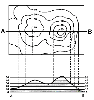
a. Lay a strip of paper along a line across the area where the profile is to be constructed.b. Mark on the paper the exact place where each contour, stream and hill top crosses the profile line.
c. Label each mark with the elevation of the contour it represents.
d. Prepare a vertical scale on profile paper by labeling the horizontal lines corresponding to the elevation of each index contour line.
e. Place the paper with the labeled contour lines at the bottom of the profile paper and project each contour to the horizontal line of the same elevation.
f. Connect the points.